Severe threat has ended, rain ending overnight
Posted: Jun 14, 2017 8:43 PM EDT

-
1:26

Wet, warm & windy this weekend
-
4:24

Michiana Crime Stoppers shredding event
-
1:16

’IvyCares’ program setting students up for success in and...
-
1:45

Windy and wet this weekend, but unseasonable warmth as well
-
3:13

Local players react to $3 million investment in Byer Softball...
-
0:32

Layoffs at Whirlpool could affect workers in Benton Harbor
-
1:03

Annual District Sisterhood Conference at Ivy Tech empowers students
-
1:49

Back home in downtown South Bend, YMCA to open new location
-
2:16

This week’s ABC57 Cub Reporter is Nicholas Zentz
-
3:05

Amazon Web Services invests $11 billion to build data center...
-
4:05

Riley High School student center stage at the NFL Draft
-
1:35

Rain, wind, and milder temperatures forecast this weekend

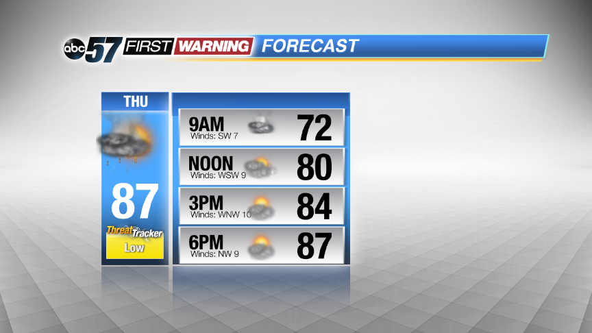
The severe threat is over, steady rain continues until after midnight then ends by Thursday morning. The forecast stays muggy, with a chance of showers and storms through the end of the week. This is a typical summertime weather pattern, storms develop in the late afternoon but may be highly scattered. The severe threat looks low Thursday, in what could be the driest of the next three days.
Tonight: Scattered showers and storms. Some could be strong to severe. Lows near 70.
Thursday: Morning showers and storms then partly sunny, high in the upper 80s.
Friday: PM scattered storms, highs in the upper 80s.
Saturday: More scattered showers and storms, highs in the upper 80s.
Sign up for the ABC 57Newsletter