Threat of flooding not immediate, but could be building for Michiana


After a dry day across Michiana on Monday, steady rain has returned to the area Tuesday. Rain chances will persist throughout most of Tuesday night and for portions of Wednesday.
Steady rain and breezy tonight. https://t.co/81y0RPEq1H | #inwx #miwx pic.twitter.com/vcmieIErE5
— Tom Coomes (@TomCoomes) March 22, 2022
Rainfall amounts could top an inch in many locations by the end of Wednesday, with a few heavy downpours possible tomorrow.
Rainfall Estimates ☔️
— Tom Coomes (@TomCoomes) March 22, 2022
Tuesday has the more constant rainfall +0.5” / 24 hrs
Wednesday will have scattered t-showers w/ downpours +0.5” / 6 hrs. https://t.co/81y0RPEq1H | #inwx #miwx pic.twitter.com/uDor5RNHfJ
While flooding is not a major concern in the short term for Michiana, we will have to keep an eye on river levels if the rain keeps up. Right now, a few area rivers and streams are near flood stage, like the St. Joseph River in Niles.
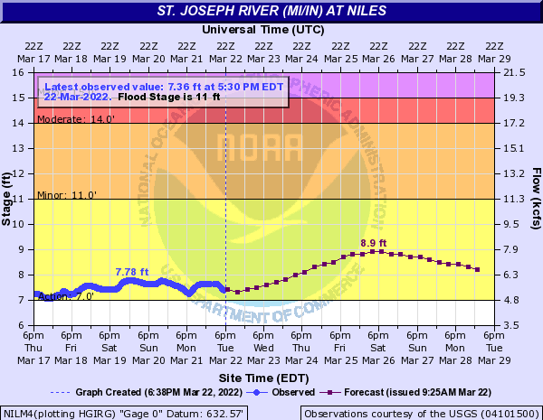
Currently, the forecast crest of approximately 9 feet is still below minor flood stage. However, with more wet weather possible this weekend and at times next week, a gradual flood threat could be building across the area into April.