
-
1:00

NIPSCO workers rally in South Bend for new contract
-
1:53

Severe weather threat is over, MUCH colder Friday
-
3:43

South Bend Mayor James Mueller delivers 2026 State of the City...
-
0:52

Family and friends of Adrian Cruz voice frustration in sentencing...
-
2:13

Potawatomi Zoo prepares for opening day with new attractions
-
2:54

Local expert weighs in on landmark social media decisions
-
1:33

Round one of storms moving east, Round two arriving soon
-
2:38

Bourbon residents recall tornado as severe weather strikes again
-
1:34

Tornado threat decreasing, but severe weather still expected...
-
1:42

Damaging winds and hail move in this evening
-
2:51

Severe weather expected in Michiana later today
-
2:15

Severe weather likely for portions of Michiana later today

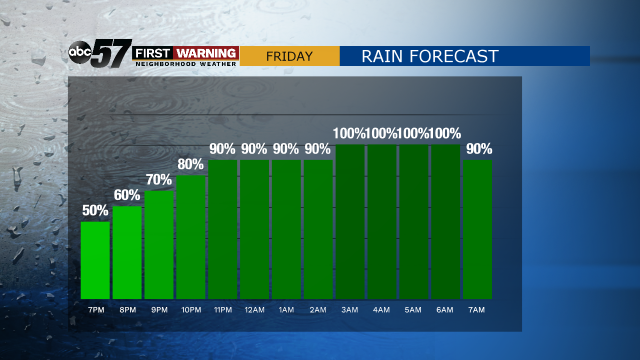
This morning is mostly dry, although some areas of fog/drizzle are possible early. The majority of Friday is dry and cloudy. The high temperature warms to 58 this afternoon. Showers start late afternoon, with heavier rain possible in the evening and overnight.
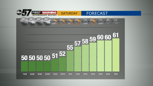
Scattered thunderstorms are possible on Saturday. The biggest threats are small hail, strong winds, and periods of heavy rain. Precipitation stops by Sunday morning, but the gusty winds continue through Sunday evening.
Next week looks mainly dry, with high temperatures around 50 each day.
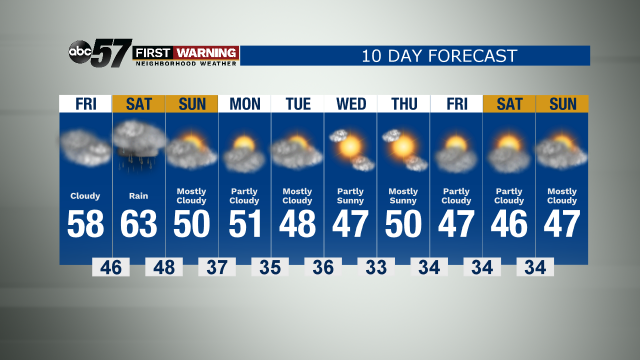
Today: Cloudy. Afternoon showers then evening rain. High 58.
Tonight: Rain. Isolated thunderstorms possible. Low 46.
Saturday: Rain and scattered thunderstorms. High 63.
Sunday: Few AM showers, then mostly cloudy and breezy. High 50.