
-
1:03

Mentone Egg festival brings a clutch of people to enjoy its history
-
0:46

9th annual Hall of Heroes Comic Con concludes its first day
-
2:39

South Bend Barber celebrates retirement after 59 years
-
0:45

OC fireworks reveal their new showroom
-
0:57

Thousands take part in Sunburst Run to raise funds
-
2:00

Annual Studebaker car show takes over Ironwood Plaza
-
0:55

Beautiful weekend expected
-
1:05

Truly wonderful conditions
-
0:41

One person left with serious injuries after high-speed pursuit...
-
2:15

Fort Wayne Tin Caps put an end to the SB Cubs winning streak
-
1:21

This weekend is the annual Hall of Heroes Comic Con
-
0:46

Elkhart Police Department respond to shots fired call at the...

Steady rain is likely to continue overnight Monday into Tuesday morning with temperatures slowly falling into the 40s.
The soggy weather continues Tuesday with little to no warm-up in temperatures. The official high for Tuesday may come just after midnight in the 50s but the waking hours will be in the mid to upper 40s. Final rainfall estimates through Wednesday morning could be more than three inches since Monday. Our first frost may be in the forecast Thursday morning.
Tonight: Rainy, low 46. 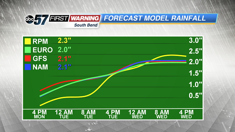 Additional rainfall estimates from Monday afternoon to Wednesday afternoon. We could see another 2
Additional rainfall estimates from Monday afternoon to Wednesday afternoon. We could see another 2
Additional rainfall estimates from Monday afternoon to Wednesday afternoon. We could see another 2
Tuesday: Cloudy and rain, temperatures in the mid to upper 40s.
Wednesday: Mostly cloudy with lake effect rain. High of 48.
Thursday: Chilly start, mostly sunny with highs near 60.