Expect more days with near-record humidity & moisture
Posted: Jun 19, 2018 2:49 PM EDT
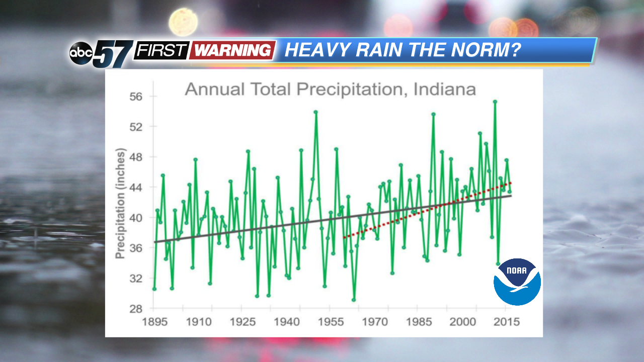
Year after year, it seems as though we see more days with hotter temperatures, higher humidity and heavier rainfall. If you break things down and look at the data, there would be plenty to back that statement up. In Michiana, we are seeing more days with dew points above 70° and more days with heavy rainfall events. What it boils down to is the warming atmosphere. As the atmosphere warms, the amount of water content that can be held within clouds rises. The result? More chances for heavy rain, downpours and flash flooding.
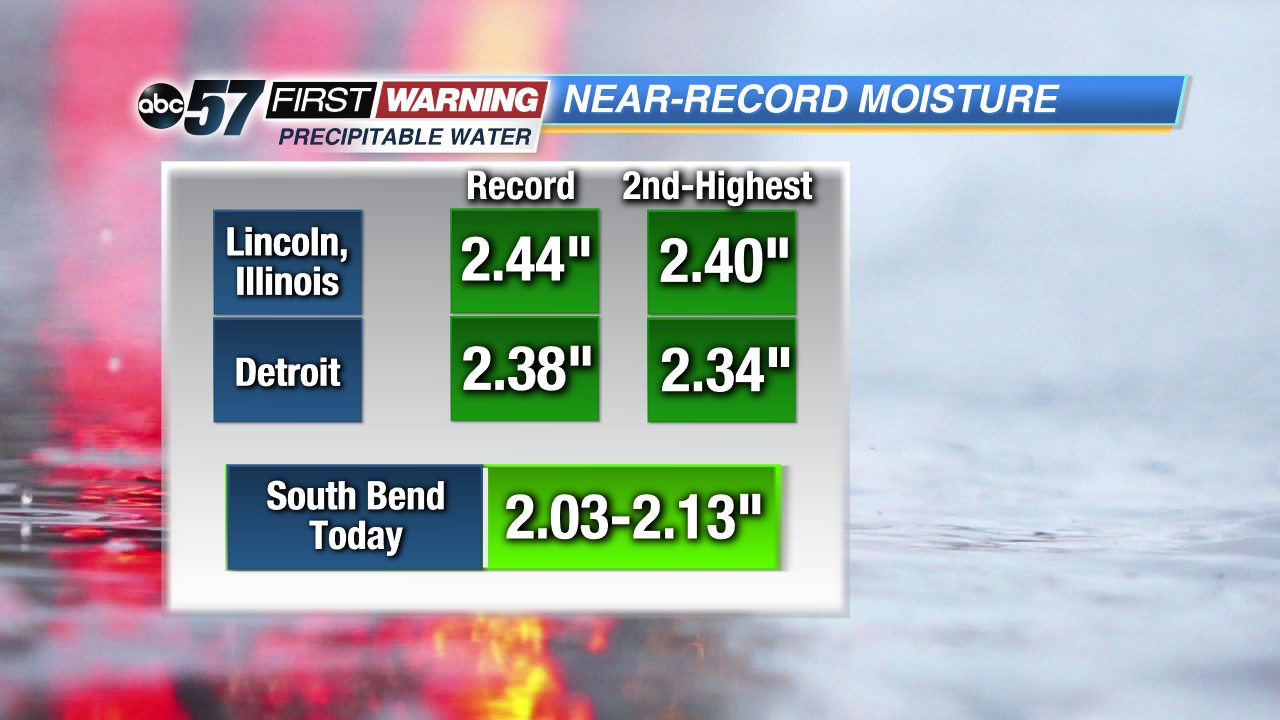
One way to investigate the threat for heavy rain is by looking into what meteorologists call precipitable water. Essentially, precipitable water is the amount of water that would fall out of a column of the atmosphere, if all of that water were precipitated as rain. These values can range from zero to a little over three inches. In Indiana, most summer days see precipitable water values between 0.75" and 1.5". The higher the precipitable water values, the more likely heavy rain and flooding becomes. Once values exceed 1.5" and especially 2", torrential rain and flash flooding become significant threats. On Tuesday, South Bend had precipitable water values as high as 2.13" or so. That is an extremely high value for northern Indiana, and is nearly as high as it gets at this latitude. Official records for precipitable water are not kept in northern Indiana, but nearby cities such as Detroit and Lincoln, Illinois, do keep tabs on it.
The all-time highest values in those cities are around 2.4". You can see that South Bend wasn't far off from those historical values. And, it's values like these that are becoming more common during the spring and summer. Even in the winter, Michiana is seeing more moisture and heavier rain events.
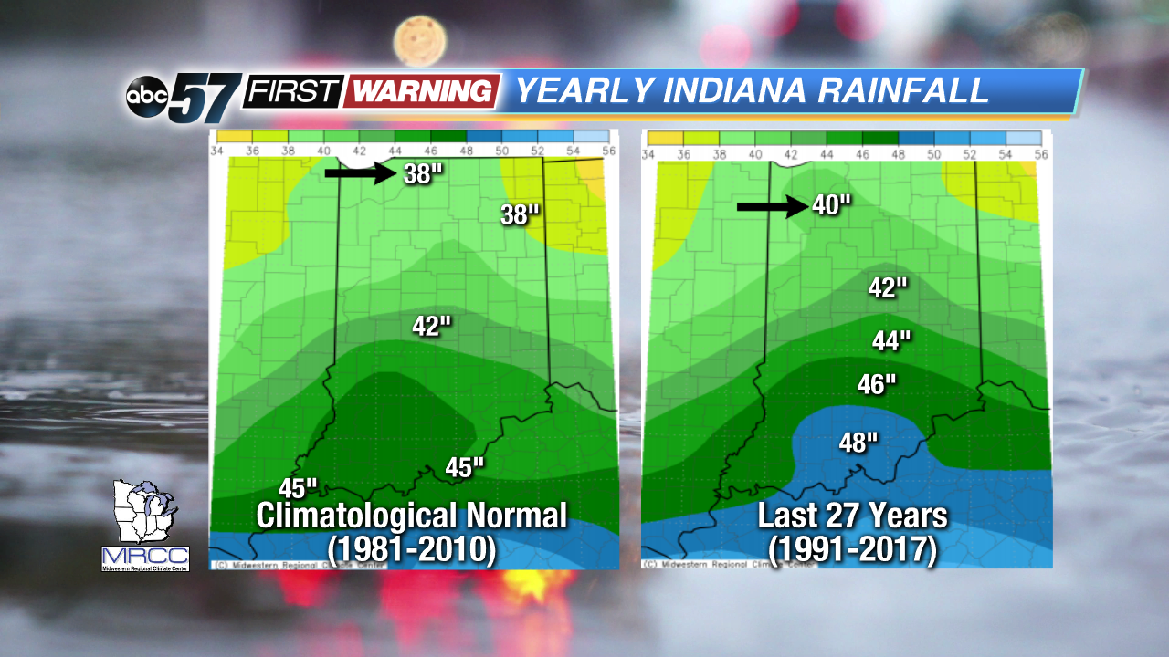
These air masses with extremely high amounts of moisture and humidity are allowing more and more heavy rain events to occur. According to the current 30-year climatological average, South Bend sees just over 38" of rain per year. If we take a look at the most recent data between 1991 and 2017, though, South Bend's average has jumped to nearly 40" per year. That is a substantial change in just a handful of years. At that pace, the city could be averaging 50" of rain per year by the end of the century. That same story exists for the rest of Indiana and all of Michigan as well. Average annual rainfall amounts are on the rise from Evansville and Indianapolis to Detroit, Grand Rapids and the Upper Peninsula of Michigan.For more information on this topic, please take a look at this slideshow prepared by the National Weather Service in North Webster, Indiana. In the meantime, expect additional moderate to possibly heavy rain by Friday and Saturday after a brief break late Wednesday and Thursday.


