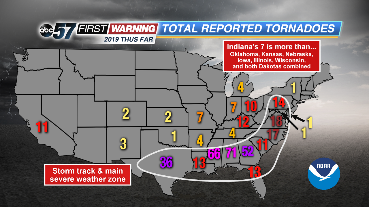
No county in Michiana has been put under a tornado watch or tornado warning thus far in 2019. That will likely change in the near future. To this point in 2019, the pattern has not favored tornadoes in the Midwest or Great Lakes. However, it has been an active year from Texas to Virginia. That's because that's the stretch where the ingredients for tornadoes and severe weather have been in place.
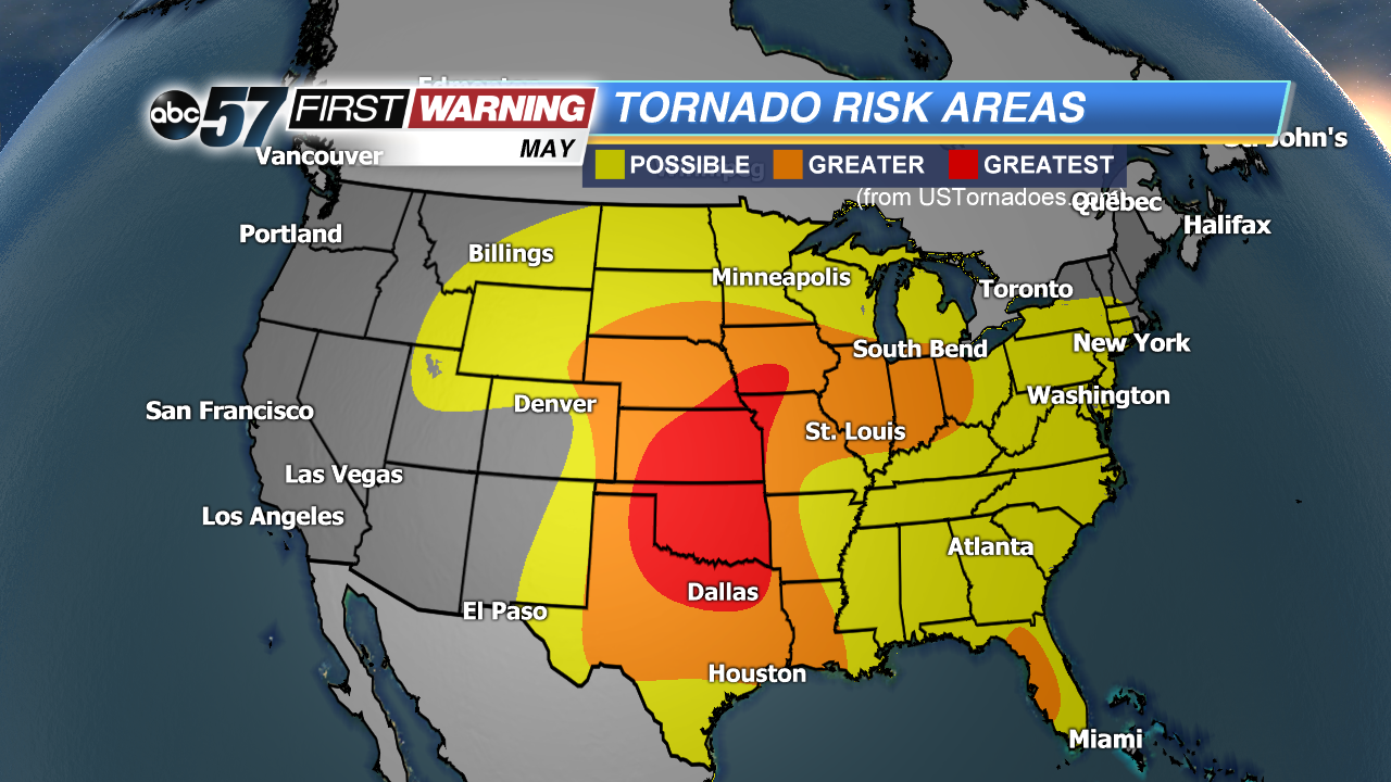 Tornado risk areas for May.
For most of the Midwest and Great Lakes the year has gotten off to a rather quiet start. Patrick Marsh, the Warning Coordination Meteorologist with NOAA's Storm Prediction Center, says that doesn't mean anything:
"Just because it’s cool now does not necessarily mean that it’s going to stay cooler and the storm track is going to stay suppressed all year. Eventually the warm air is going to come back. The moist air is going to come back. And so, once you start to put those ingredients in place, the severe weather risk in your area is going to increase rapidly."
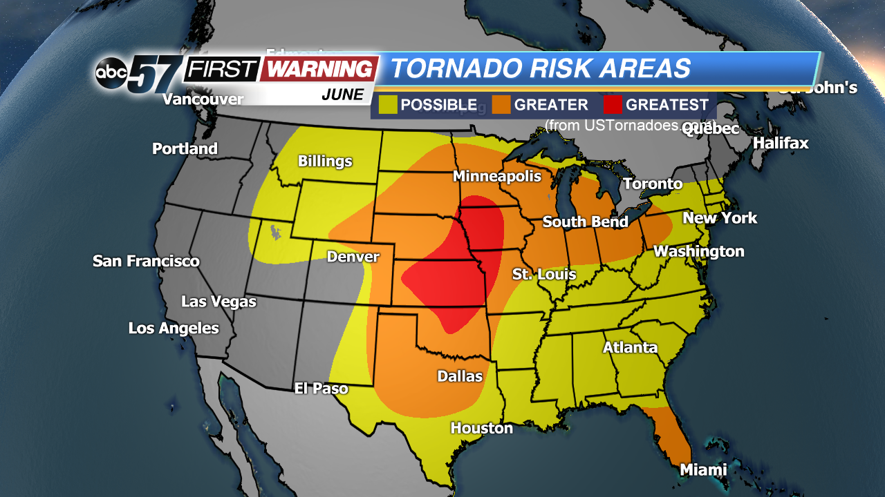 Tornado risk areas for June.
He went on to say that, "For Northern Indiana and Southern Michigan, that general area, the peak severe weather season for you guys tends to fall in late June, early July." That's the absolute peak for severe weather and tornado reports for most years in Michiana. However, severe weather and tornadoes do exhibit an overall spike from mid-May thru early August. You can see that Michiana falls in the "Greater" category for tornado risk during the months of May, June and July.
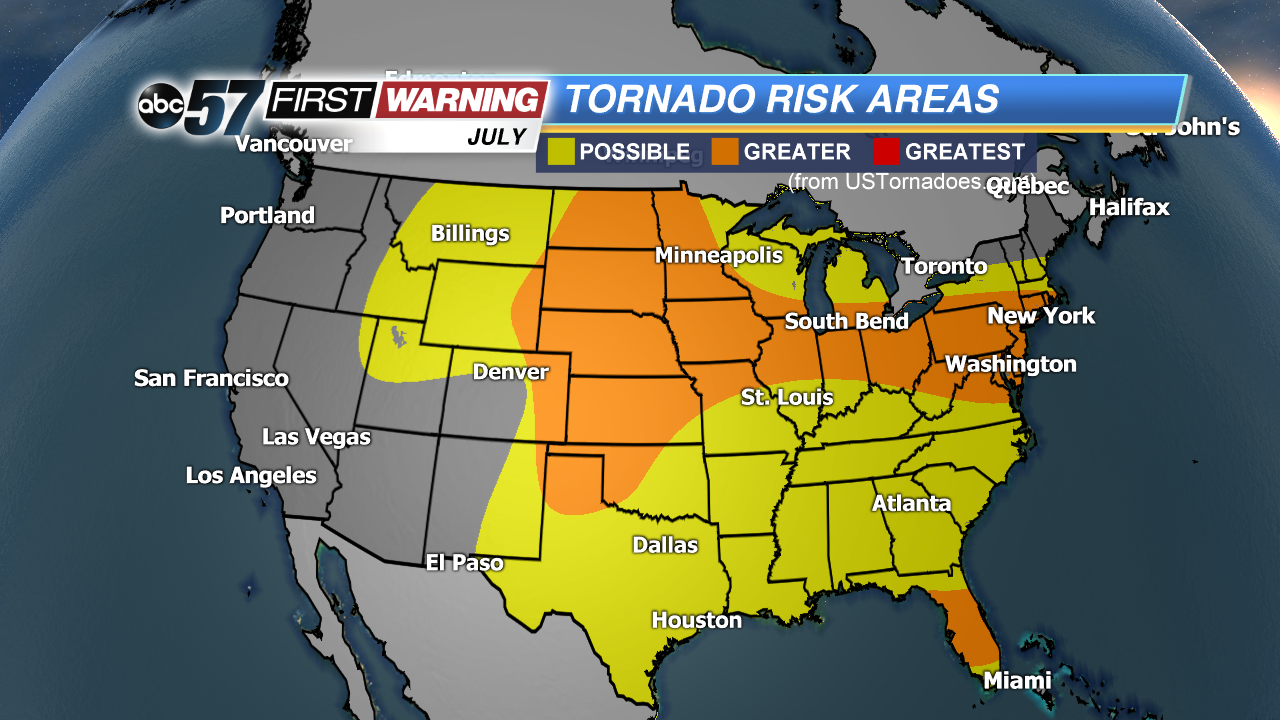 Tornado risk areas for July.
So, climatologically speaking, we should be expecting a noticeable uptick in dangerous thunderstorm and possibly tornado activity after Mother's Day. But is there another way to look into the likelihood of tornadoes in this part of the country? Well, there are several ways to analyze tornado activity, tornado hot spots, tornado probabilities, and areas most at-risk for tornadoes.
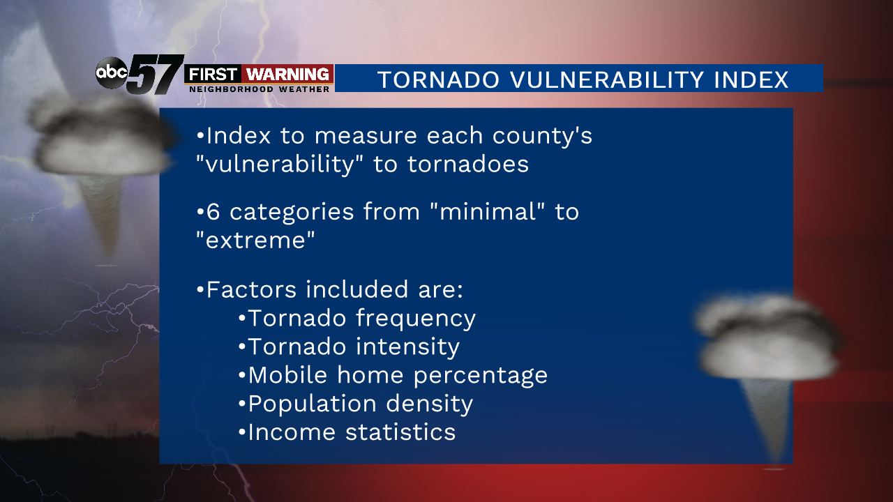
 Tornado Vulnerability Index
Ethan Rogers
Tornado Vulnerability Index
Ethan Rogers
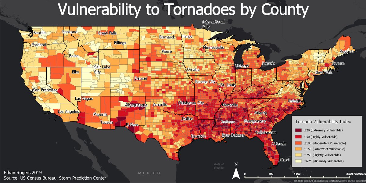
One that was just released on April 23rd by Ethan Rogers is called the
Tornado Vulnerability Index. The index is a numerical display of how every county in the contiguous United States is vulnerable to life and property loss in the event of a tornado. It combines four factors:
•Tornado frequency and intensity as one single factor
•Mobile home concentration
•Population density in each county
•Median income per household
Based on those four ingredients, each county is assigned a value and is colored accordingly on the map. White and yellow counties are considered to have low vulnerability, while dark red counties are deemed very vulnerable. The different rankings are as follows:
•Minimally vulnerable
•Slightly vulnerable
•Somewhat vulnerable
•Moderately vulnerable
•Highly vulnerable
•Extremely vulnerable
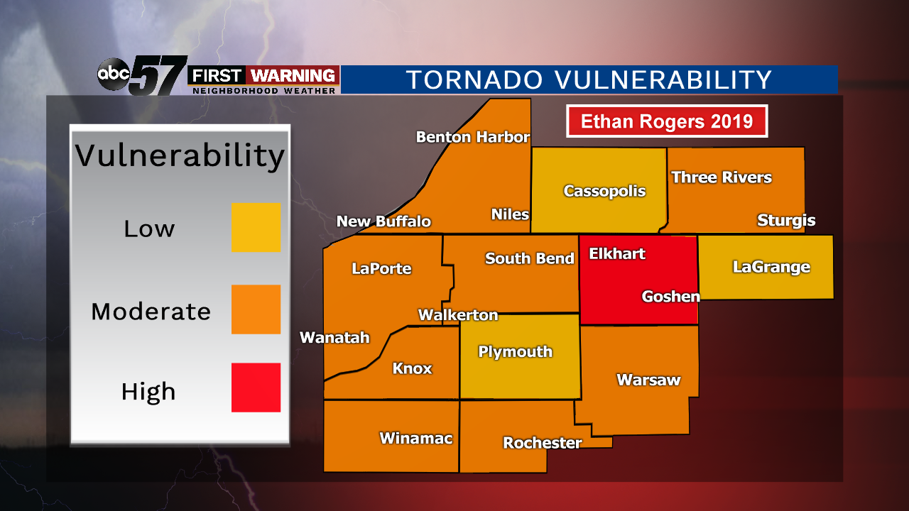
Rogers says that, "If you are in a darker red shade, your county is more vulnerable to life and property loss due to these factors, whether it's because of lots of mobile homes or a high population below poverty."
 Ethan Rogers
Geographical areas that have the highest vulnerability to tornadoes include the Deep South and Southeast, the Tennessee Valley, New Mexico, and isolated counties across the Great Lakes and Midwest. A few nearby cities that find themselves highly vulnerable to tornadoes include Chicago, Flint, Indianapolis, Champaign-Urbana, and Elkhart County right here in Michiana. We asked Marsh about the index and if it's plausible. He says, "Scientifically, yes, you can do something [like make an index]. But we have to be careful here. The last thing we want to do is tell people 'you are in a dark red county, you are in a bad location.' When you see these vulnerability maps, don't necessarily take it as 'there's nothing I can do.' There's a lot that you can do and by taking simple actions, you can decrease your vulnerability [to tornadoes]."