We are just days away from the unofficial start to summer with Memorial Day weekend quickly approaching! It's also a big weekend to get outside. Most of us will be hitting the beach, laying poolside, boating, grilling out, and playing games in the yard. That means knowing everything about the weather is very important for the extended holiday weekend. Fortunately, it looks like a perfect "summery" weekend is shaping up for all of Michiana.
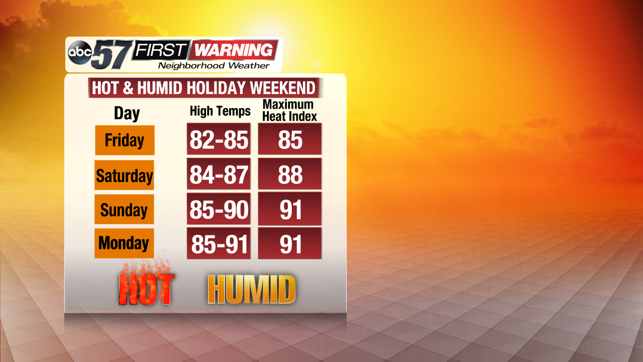
Friday, Saturday, Sunday, and Monday will all be very warm to plain hot. Temperatures will soar well into the 80s and possibly touch 90° for the first time this year in spots. The humidity will be very noticeable as well as the weekend progresses. In particular, Saturday, Sunday and Memorial Day look to feature dew points in the upper 60s. That would qualify as "very humid" to "muggy." Adding the hot temperatures and high humidity together results in "feels like" temperatures, or heat indices, that are a few degrees higher than the actual air temperature. All weekend long temperatures will likely "feel" like they are in the upper 80s to lower 90s during the afternoon and early evening hours.
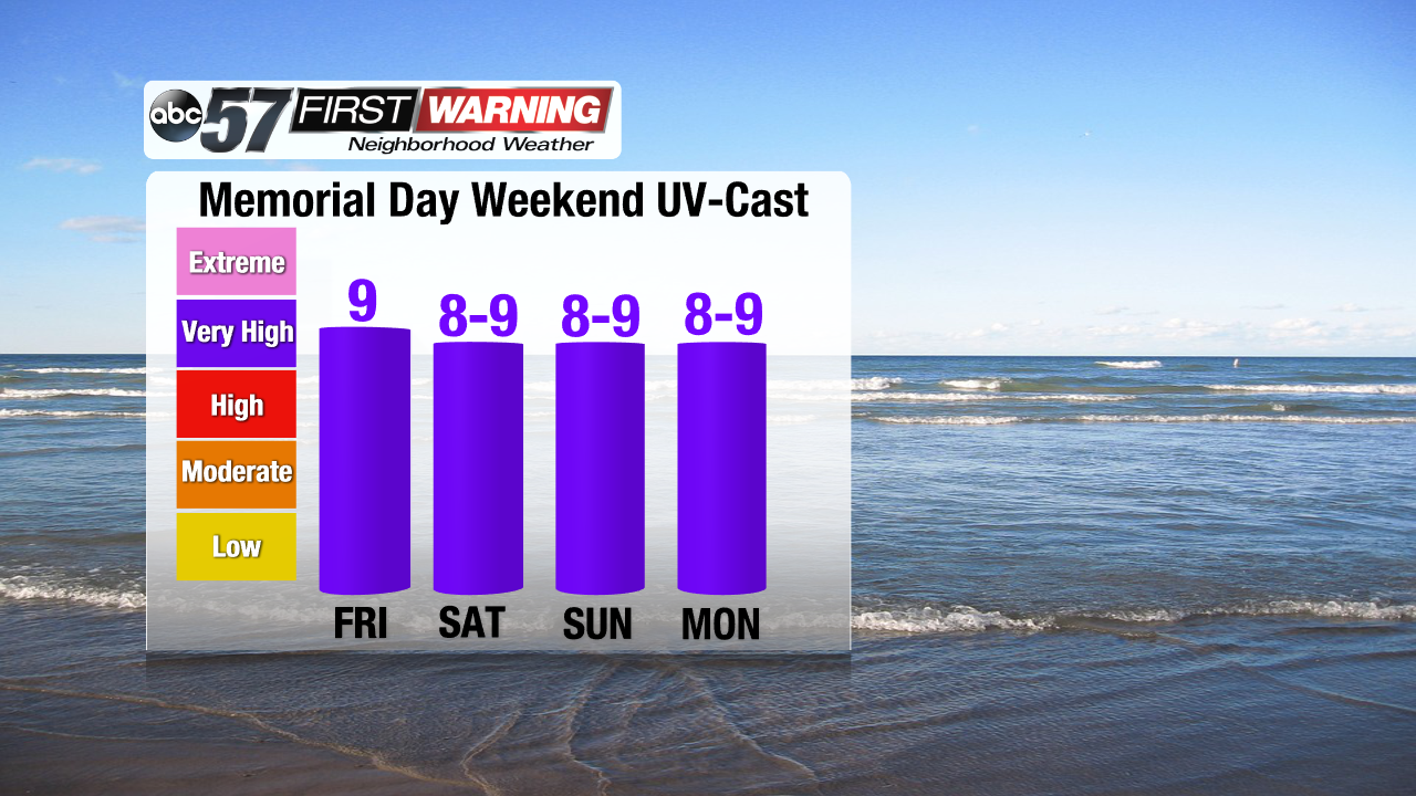
The late morning and afternoon hours will not only be toasty. They will also feature a high chance of sunburn. That's because the sun angle continues to increase as the sun climbs higher into the sky through May. The result is a weekend with UV Index values in the 8-9 range, if not higher. Sunburn can happen in well under 30 minutes in direct sunlight between the hours of 10 AM and 5 PM with values that high. Be sure to apply sunscreen a half hour before venturing outdoors. It's also recommended that you reapply if you plan on entering any sort of water.
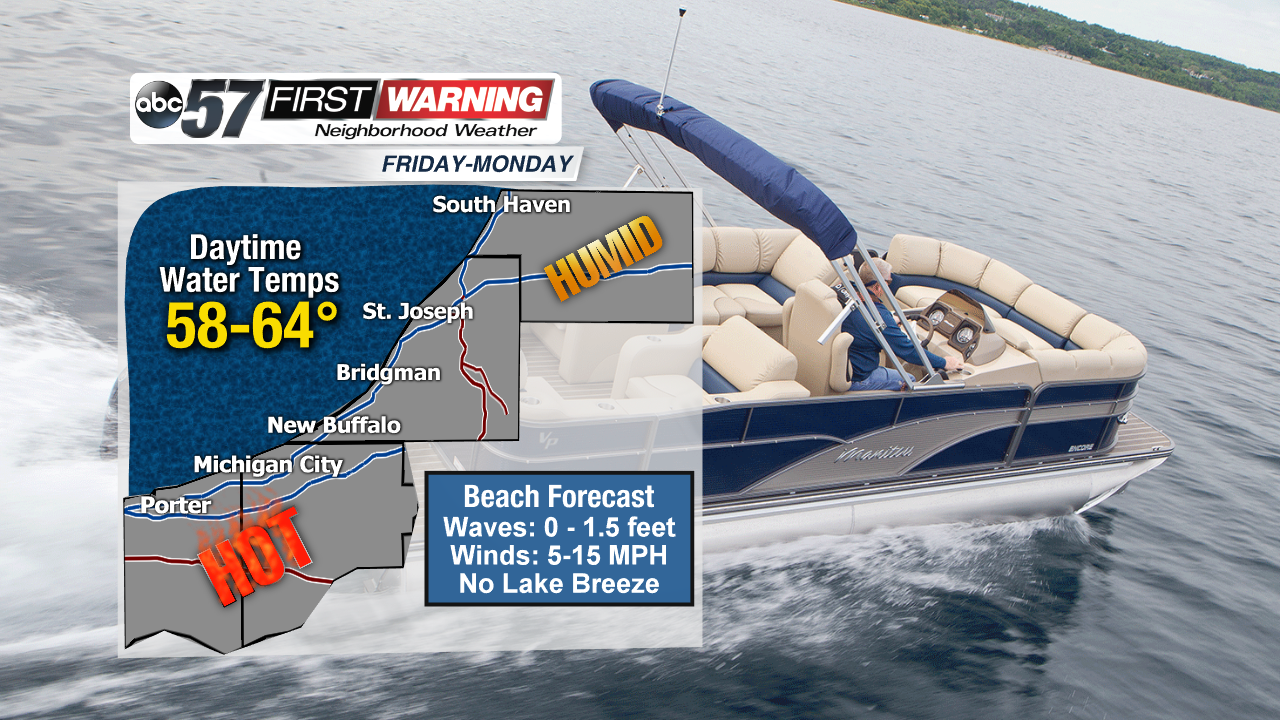
Speaking of entering the water, Lake Michigan and the beaches along the shore will be popular destinations for many this weekend. Obviously pools will be chilly, but what about Lake Michigan waters? Well, they will be chilly, but they'll be more bearable by the holiday weekend. Lake temperatures along the coast will range from the upper 50s to lower 60s during the daytime hours this weekend. That is tolerable compared to the upper 40s and lower 50s we have today! Waves will be held in check and remain below 1.5 feet thanks to calm waters and winds staying light all weekend long. That means our rip current threat will be very low throughout the weekend.
Lastly, what about any precipitation chances? The weekend will see much more dry time than wet time. There could be some isolated to possibly scattered showers and thunderstorms at just about any point this weekend, but Saturday evening features the best chance at about 30-40%. Otherwise, there may be a few pop-up thundershowers Sunday and Monday, but nothing of significance.