
-
1:03

Lighter rain expected into the afternoon
-
1:04

Non-severe storms expected
-
1:16

Showers start this morning
-
1:59

Mac & Cheese festival turns Four Winds Field into a kitchen
-
0:45

Michiana Spring Clay tour encourages people to try and take a...
-
2:56

Fresh Cuts, Fresh Starts: Re-Entry Program Gives Back in Elkhart
-
0:53

Jr. Irish Memorial Day invitational celebrates veterans and active-duty...
-
1:15

Another rain chance this holiday weekend
-
0:46

Holiday weekend starts rainy
-
1:13

South Bend West Side Memorial Day Parade Preview
-
0:48

Three Rivers Menards partially reopens after suffering extensive...
-
1:53

Reactions from race fans at Plymouth Motor Speedway to the passing...

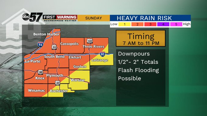
The heat and humidity peak Saturday as highs surge into the upper 80s, thanks in part to a southerly breezy gusting up to 30 mph. Sunday is the transition day, rain is likely, with possibly thunderstorms. Downpours could bring more than one inch in total rainfall through Monday morning. The start of next week will feel more like fall but the warm season does not look to be over yet.
Tonight: Mostly clear. Low of 66.
Saturday: Partly cloudy, breezy. High of 88.
Sunday: Showers and storms, heavy rain possible. High of 78.
Monday: Partly cloudy. High of 70.
Sign up for the ABC 57 Newsletter