
-
1:06

Mishawaka Fieldhouse features Adidas 3Striped basketball tournament
-
2:04

Elkhart high school football players got out on the gridiron...
-
1:04

Local market event raises funds for the family of Kaylon Woods
-
2:48

Former South Bend Cub Nico Hoerner reflects on path to Chicago...
-
1:00

Medieval times return to Plym Park with the Renaissance Faire
-
2:15

South Bend celebrates Kids to Parks Day with bike-riding workshop
-
2:43

Cubs clobber White Sox in first game of ’Crosstown Classic’
-
2:00

South Bend Police Department honors the fallen
-
0:52

St. Joe/Benton Harbor Rotary holds ribbon-cutting ceremony for...
-
2:25

Irish lacrosse head to NCAA quarterfinals with Johns Hopkins...
-
3:09

Cubs, White Sox open first Crosstown Classic series of summer...
-
3:45

South Bend Cubs dedicate plaque to Indiana born composer of ’Take...

Rain changes to a slushy snow overnight, accumulation of one to three inches possible but will likely melt on most paved surfaces. Wet and slushy travel is expected Monday night and Tuesday morning.
Wintry weather returns midweek, snow changes to rain showers Tuesday afternoon and then changes back to snow again Tuesday night. Snow showers could bring an additional inch or two through Wednesday. However overall accumulation will stay to a minimum, due to melting, as high temperatures waver just above freezing. Temperatures remain below normal through the end of the week.
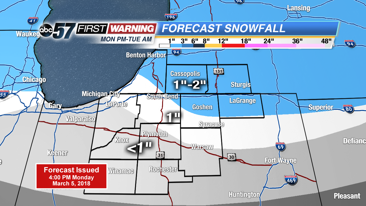
Tonight: Wintry mix turning snow, low of 30.
Tuesday: A few morning snow showers, mostly cloudy with afternoon rain changing to snow, high of 40.
Wednesday: Mostly cloudy, light snow and windy, high of 33.
Thursday: Mostly to partly cloudy, chance of snow, high of 30.