
-
1:02

Chicory Cafe celebrates St. Patrick’s Day with corned beef...
-
2:43

City of Elkhart, EPA, IDEM prepare for removal of contaminated...
-
2:58

South Bend goes green for St. Paddy’s Day at Fiddler’s Hearth
-
2:32

St. Joseph County boards, City of Mishawaka, approve Memorandum...
-
2:40

More than just fighting fires: Warsaw fire official helps with...
-
1:38

Snow Wednesday, rain Thursday, mild Friday
-
2:11

Snow wrapping up today, returns tomorrow
-
4:39

The Morris debuts its 2026-27 season lineup
-
2:25

Lake effect snow through this morning
-
0:25

City commission approves new downtown paid parking plan
-
3:41

Community shares concerns at board meeting over offensive language...
-
2:03

Staying safe around downed power lines

More winter weather Tuesday evening through Wednesday morning. Steady light snow, a range of 1” to 3” in combination with already slick conditions and wind gusts up to 45 mph will continue to make travel hazardous.
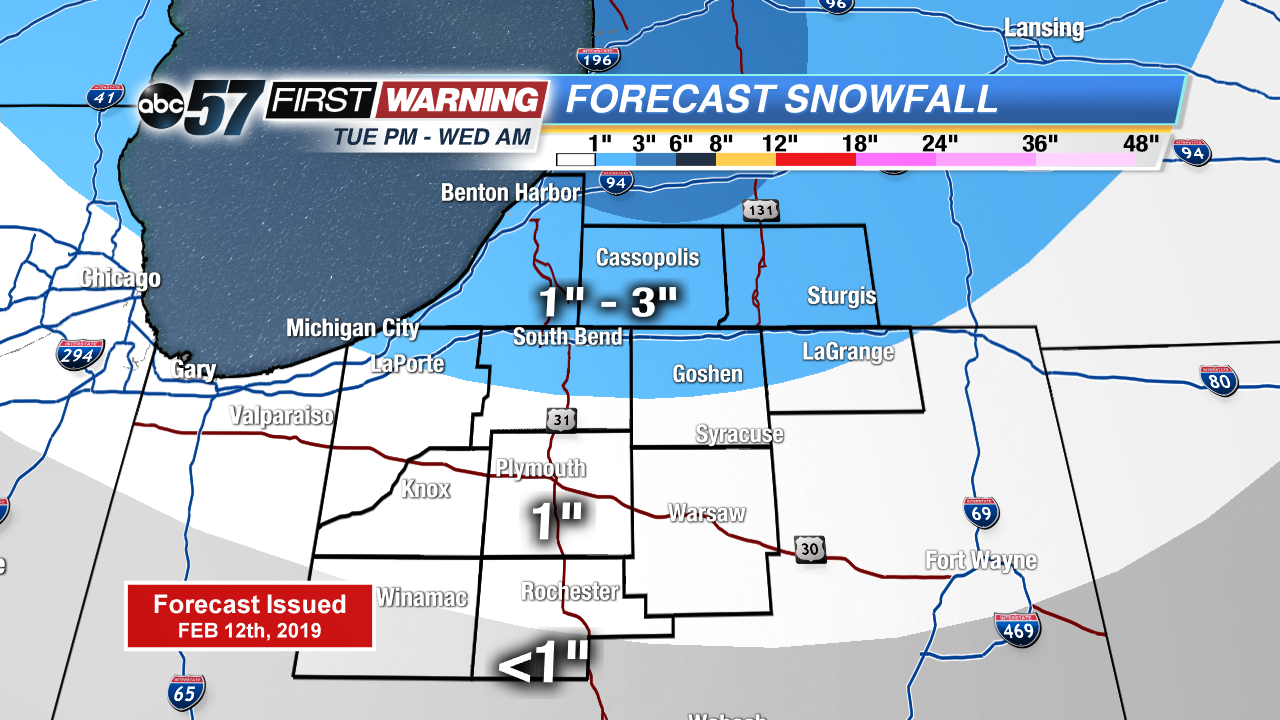
Snow comes to an end Wednesday morning, blustery conditions will continue as temperatures struggle to reach 30. Temperatures take a swing upwards Thursday into the 40s as rain returns, changing back to snow Friday. Icing is less of a concern Friday morning as pavement temperatures will have warmed above freezing.
Tonight: Snow showers, low of 22.
Wednesday: AM lake effect snow, cold and breezy, high of 30.
Thursday: Mostly cloudy, rain likely by the evening, high of 44.
Friday: Morning snow showers, temperatures fall from 30.
Sign up for the ABC 57 Newsletter