Staying cool over the next couple of days
By: Alex Countee
Posted: Jun 25, 2017 8:01 AM EDT

-
1:48

Preparations underway as Indiana University football trophies...
-
3:09

Indiana Utility Regulatory Commission collecting consumer data...
-
1:18

St. Joseph County officials host Election 101 Workshop on voting...
-
5:36

Hannah Hidalgo wins Naismith Defensive Player of the Year
-
2:50

New South Bend Cubs manager Daniel Wasinger ready for opening...
-
2:24

South Bend Cubs pitcher Kenten Egbert looks to build on strong...
-
1:52

Hoosiers face a gas tax increase as gas prices continue to rise
-
1:45

Iranian cybercrime group claims to have hacked St. Joseph County’s...
-
1:17

Cold and soaking rain today, another severe risk tomorrow
-
0:44

South Bend High School Music Festival highlights student talent
-
1:55

South Bend house fire possibly caused by lightning
-
2:26

Flooding remains a threat into Wednesday

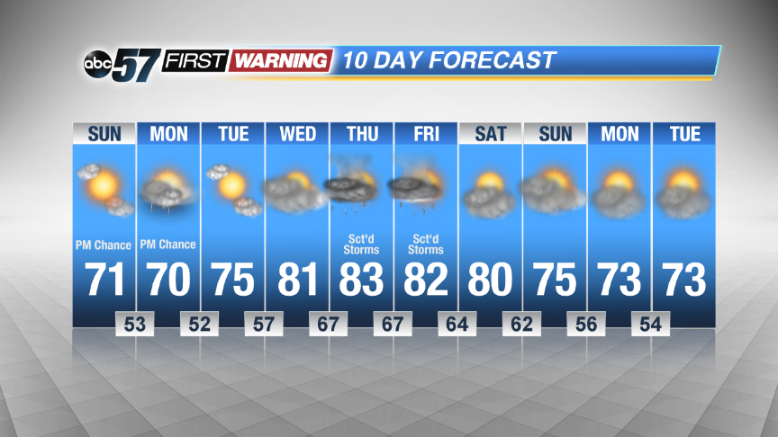
Our highs will be staying in the lower 70s for the next couple of days. Over that stretch, we’ll still have slight chances for afternoon showers today and Monday. Starting Tuesday, temperatures start to climb back into the 70s and 80s as early as Wednesday. Storm chances return to the forecast as well beginning Wednesday night and persisting through Friday night. Next weekend looks dry as we save a few degrees off our afternoon highs.
 Cool today and tomorrow but highs return to the 80s later in the week.
Sunday: Mostly sunny with a slight chance of an afternoon shower or storm, high 71.
Tonight: Mostly cloudy with more slight chances of showers. Low of 53.
Monday: Partly sunny with chances of passing showers, highs near 70.
Tuesday: Mostly sunny. Highs in the mid 70s.
Sign up for the ABC 57 Newsletter