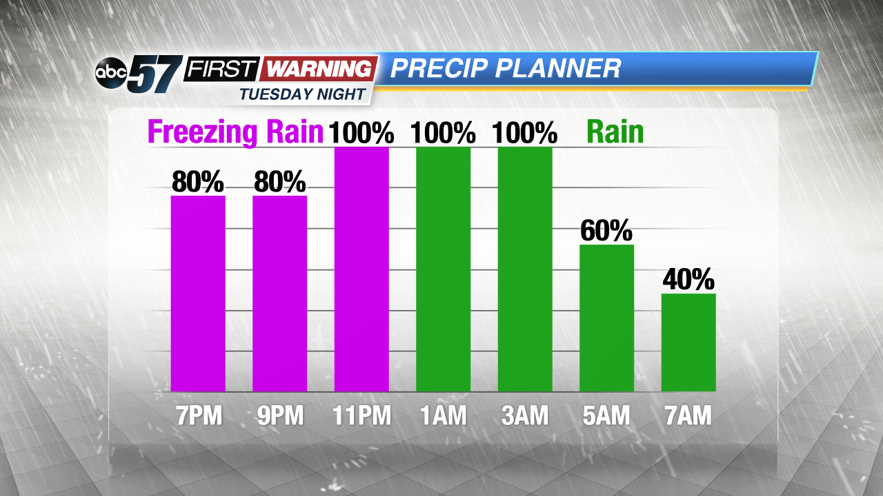
Tuesday's temperature swing brings concern for freezing rain

-
4:21

ABC57 announces the Jennifer Copeland Memorial Scholarship Fundraising...
-
1:05

Notre Dame’s Comfort K9 program is breaking down barriers,...
-
2:23

Notre Dame softball rallies past DePaul in regular-season finale
-
3:04

Berrien County Community asks Sheriff to withdrawal from partnership...
-
3:33

Notre Dame alum crucial part of Artemis II mission
-
1:55

The UAE is leaving OPEC soon, here’s why
-
3:02

City of Benton Harbor facing “dire“ financial situation
-
3:17

Shawn Akison sentenced to 12 years for 2025 multi-vehicle crash...
-
5:24

Mayor Mueller discusses the questions of data centers and spring...
-
2:01

South Bend Cubs open 12-game homestand with win over Fort Wayne
-
1:11

Cloudy and cool weather today
-
4:40

Ivy Tech South Bend-Elkhart serves up food rescue program

A swing in temperatures Tuesday into Wednesday will bring a wintry mix of weather, the top concern being freezing rain Tuesday evening. Temperatures rise from the single digits into the 20s Tuesday afternoon, as a chance of snow builds. Temperatures rise toward 32 degrees Tuesday evening, window for freezing rain looks to be between 6:00 p.m. and midnight. All rain early Wednesday before temperatures crash again. A very cold and active winter pattern continues in the extended forecast.
Tonight: Partly to mostly cloudy, low of 4.
Tuesday: Mostly cloudy, snow →sleet → freezing rain → rain builds into the evening, breezy with a late high of 34.
Wednesday: Morning mix changing to snow, temperatures falling from an early high of 34 degrees.
Thursday: Lake effect snow showers, high of 24.